Basemaps and Street View™
By Nathan ColeUpdated
Routing24 runs on two basemaps. The planning features work the same on both. What changes is the map imagery, the address search behind it, and Street View™.
OpenStreetMap on the free tier
The OpenStreetMap basemap is a full world map rendered with MapLibre. Everything described in Navigating the map works on it: zoom, search, right-click lookup, route colors. Address search and the right-click lookup run on OpenStreetMap data, which covers regular street addresses well but has fewer business names and points of interest.
Google Maps™ on Starter and Pro
The Google Maps™ basemap draws the same map view on Google imagery. The differences beyond the tiles:
- Google Places search. The map search box and the address fields across the app search Google's places database, with better hit rates on partial addresses, business names, and new developments.
- Google reverse lookup. The right-click lookup card resolves against Google data as well.
- Street View™, covered below.
- Google Maps™ traffic on the map.
What each plan includes is on the plans and billing page.
Street View™
A pin in exactly the right place still does not show arrival conditions: an entrance around the corner, a street too narrow for the truck, an address that is a locked gate. Street View™ shows the spot at street level before dispatch.
On the Google basemap, drag the orange figure (bottom-right corner of the map) onto any street. The view splits into two panes: the map stays live on one side and the street-level panorama opens on the other. Pins remain clickable while the panorama is open.
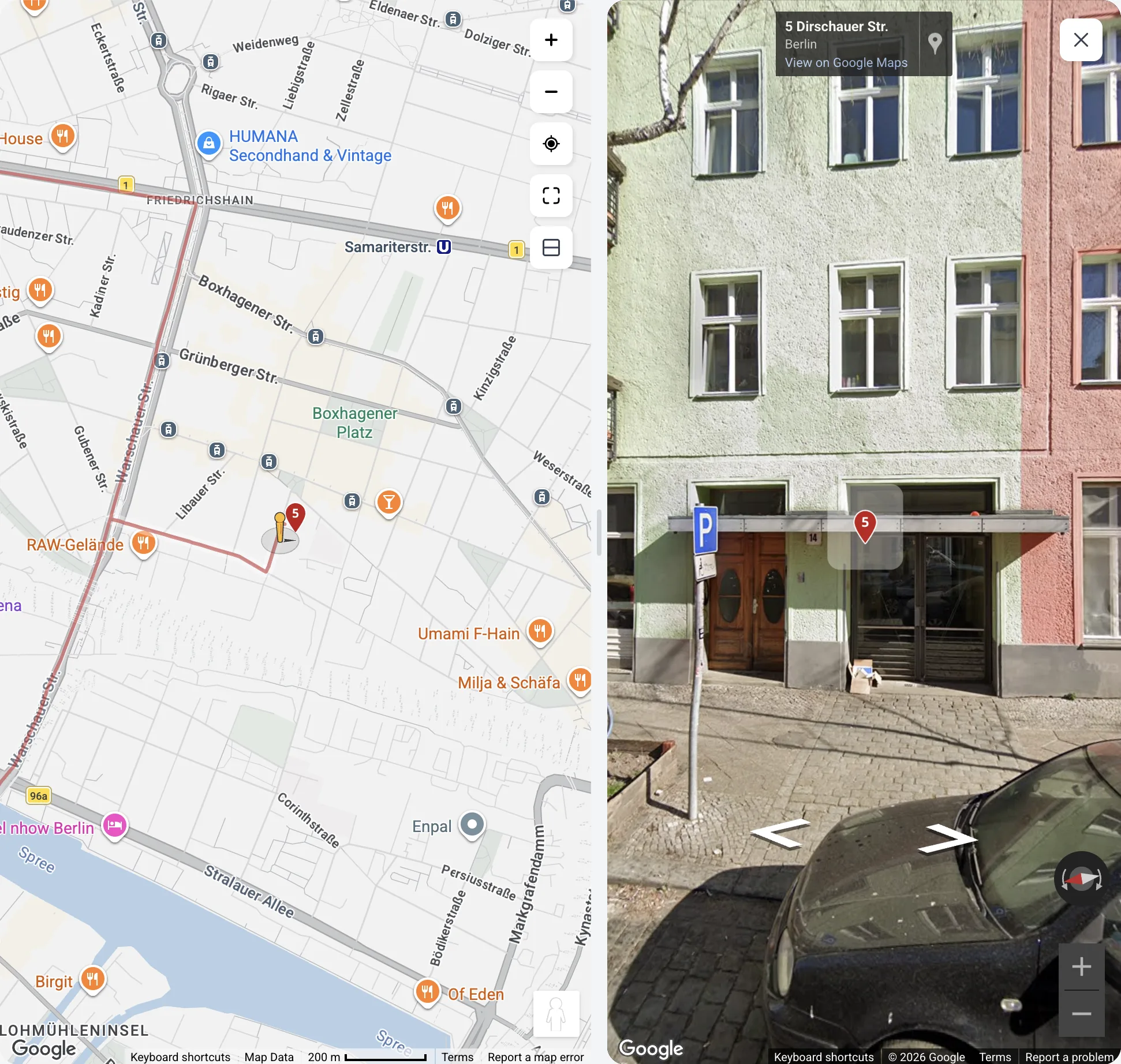
While the split view is open:
- The pins on the map appear inside the panorama itself, for locations within about 300 meters.
- Drag the divider between the panes to resize them.
- The layout button in the map's control stack toggles the split: Move Street View™ to the bottom / Move Street View™ to the right.
- Close Street View™ (the × button in the panorama's corner) returns to the full map.
A Street View™ pass over new or unfamiliar addresses shows problems the pin does not: no parking, no loading zone, a mislocated pin one building off. Fix a mislocated pin with Customize, as described in Edit orders, depots, and addresses on the map.
A plan made on one basemap opens unchanged on the other.
Next step
Send the route to the driver with Share a route with a driver.
FAQ
Which map does Routing24 use?
Routing24 runs on two basemaps: an OpenStreetMap view rendered with MapLibre, and a Google Maps™ view. The planning features work the same on both, and a plan made on one basemap opens unchanged on the other. What each plan includes is on the plans and billing page.
What does the Google Maps™ basemap add?
The Google Maps™ basemap adds Google Places search behind the map search box and the address fields, with better hit rates on partial addresses, business names, and new developments. The right-click lookup resolves against Google data. Street View™ and Google Maps™ traffic are on this basemap. Plans made on one basemap open unchanged on the other.
How do I open Street View™ on a delivery point?
On the Google basemap, drag the orange figure from the bottom-right corner of the map onto any street. The view splits into two panes: the map stays live on one side and the street-level panorama opens on the other, with the map pins drawn inside the panorama for locations within about 300 meters.
Why check a stop in Street View™ before dispatch?
A pin in exactly the right place still does not show arrival conditions: an entrance around the corner, a street too narrow for the truck, an address that is a locked gate. A Street View™ pass over new addresses shows no parking, no loading zone, or a pin one building off.